Geolocate

Peach Springs topographic map

Click on the map to display elevation.

About this map

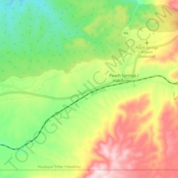
Name: Peach Springs topographic map, elevation, terrain.

Location: Peach Springs, Mohave County, Arizona, United States (35.49938 -113.47355 35.55116 -113.39039)

Average elevation: 1,493 m

Minimum elevation: 1,302 m

Maximum elevation: 1,742 m

Gear up for your next adventure:

💡LED Headlamp - Hands-free illumination for night hiking and camping
🧦Hiking Liner Socks - Thin base layer to prevent friction and blisters
💡LED Camping Lantern - Illuminate your campsite with long-lasting lanterns
🧥Waterproof Pants - Keep dry during rainy hiking conditions
🥾Light Hiking Boots - Lightweight and comfortable boots for day hikes

As an Amazon Associate, this site earns from qualifying purchases at no extra cost to you.