Geolocate

Biga topographic map

Click on the map to display elevation.

About this map

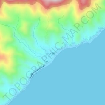
Name: Biga topographic map, elevation, terrain.

Location: Biga, Lobo, Batangas, Calabarzon, Philippines (13.62242 121.31346 13.66242 121.35346)

Average elevation: 124 m

Minimum elevation: 0 m

Maximum elevation: 614 m

Gear up for your next adventure:

💡Portable Camping Lamp - Rechargeable lamp for campsite lighting
🥾Light Hiking Boots - Lightweight and comfortable boots for day hikes
🥾Approach Shoes - Shoes designed for climbing approaches and rugged trails
🥾Waterproof Hiking Boots - Boots keeping your feet dry in wet conditions
💡LED Camping Lantern - Illuminate your campsite with long-lasting lanterns

As an Amazon Associate, this site earns from qualifying purchases at no extra cost to you.