Geolocate

Salida topographic map

Click on the map to display elevation.

About this map

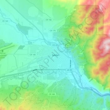
Name: Salida topographic map, elevation, terrain.

Location: Salida, Chaffee County, Colorado, United States (38.49472 -106.03890 38.57472 -105.95890)

Average elevation: 2,284 m

Minimum elevation: 2,114 m

Maximum elevation: 2,761 m

Gear up for your next adventure:

🧣Evaporative Cooling Towel - Beat the heat during intense summer climbs
💡Solar Camping Lamp - Eco-friendly lighting for campsites
🥾Trail Hiking Shoes - Durable shoes designed for rugged trails
🥾Durable Hiking Shoes - Long-lasting shoes for frequent hiking
🌬️Windproof Camp Stove - Efficient cooking even on exposed mountain peaks

As an Amazon Associate, this site earns from qualifying purchases at no extra cost to you.