Geolocate

Margao topographic map

Click on the map to display elevation.

Margao

Margao is located at 15°16′25″N 73°57′29″E / 15.27361°N 73.95806°E / 15.27361; 73.95806. It has an average elevation of 10 m (33 ft).

Wikipedia (CC-BY-SA 3.0)

About this map

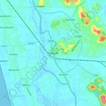
Name: Margao topographic map, elevation, terrain.

Location: Margao, Salcete, South Goa, Goa, 403600, India (15.23292 73.91832 15.31292 73.99832)

Average elevation: 18 m

Minimum elevation: -1 m

Maximum elevation: 156 m

Other topographic maps

Click on a map to view its topography, its elevation and its terrain.

Sal

India > Goa > Salcete > Parlmar Grande

Average elevation: 15 m

Gear up for your next adventure:

🥾Mountain Trail Shoes - High-traction shoes for mountain trails
🪑Ultralight Camping Stool - Compact seating for rest stops during long hikes
💡Compact LED Flashlight - Powerful and portable flashlight for outdoor use
🧥Packable Rain Jacket - Breathable waterproof layer for unpredictable weather
🛶Kayak Dry Bag - Waterproof storage for kayaking adventures

As an Amazon Associate, this site earns from qualifying purchases at no extra cost to you.