Geolocate

Pontarlier topographic map

Click on the map to display elevation.

About this map
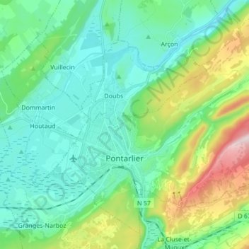
Name: Pontarlier topographic map, elevation, terrain.

Location: Pontarlier, Doubs, Bourgogne – Franche-Comté, Metropolitan France, 25300, France (46.87567 6.31146 46.95763 6.44783)

Average elevation: 906 m

Minimum elevation: 784 m

Maximum elevation: 1,293 m

Other topographic maps

Click on a map to view its topography, its elevation and its terrain.
Gear up for your next adventure:

🧰Emergency Multi-Tool - Compact multi-tool for outdoor survival
⛺Lightweight Camping Tent - Portable shelter optimized for Canadian backcountry camping
🚲Handlebar Phone Mount - View topographic-map.com live while cycling
🦟Insect Repellent - Keep mosquitoes and black flies away in wooded areas
🎒Hiking Backpack - Lightweight and ergonomic backpacks for day hikes or multi-day treks

As an Amazon Associate, this site earns from qualifying purchases at no extra cost to you.