Geolocate

Pontarlier topographic map

Click on the map to display elevation.

About this map
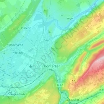
Name: Pontarlier topographic map, elevation, terrain.

Location: Pontarlier, Doubs, Bourgogne – Franche-Comté, Metropolitan France, 25300, France (46.87567 6.31146 46.95763 6.44783)

Average elevation: 906 m

Minimum elevation: 784 m

Maximum elevation: 1,293 m

Other topographic maps

Click on a map to view its topography, its elevation and its terrain.
Gear up for your next adventure:

💧Hydration Pack - Hands-free hydration system for long hikes
🧤Thermal Hiking Gloves - Grip-enhanced gloves for cold-weather altitude trekking
🧭GPS Outdoor Watch - Smart watch for navigation and fitness tracking in nature
🥾Approach Shoes - Shoes designed for climbing approaches and rugged trails
🧦Outdoor Socks - Durable socks designed for hiking and outdoor sports

As an Amazon Associate, this site earns from qualifying purchases at no extra cost to you.