Cádiz topographic map
Click on the map to display elevation.
Cádiz
The entire province of Cádiz has a Mediterranean climate, mostly Köppen Csa but also Csb in high altitude areas. Large differences in summer temperatures exist between the three official stations in Cádiz, Jerez, and Tarifa depending on position relative to the coastline. Tarifa is exceptionally mild for such a southerly place in Spain, meanwhile winter temperatures are mild throughout the province with less difference between localities than in summer. Average yearly rainfall is 521 mm (20.5 in) in Cádiz, 573 mm (22.6 in) in Jerez, and 603 mm (23.7 in) in Tarifa. This is comparable to much cloudier climates further north in Europe, in spite of the high number of sunshine hours in the province. The Cádiz region is also much wetter than the arid Almería province further east in Andalusia.
About this map
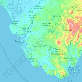
Name: Cádiz topographic map, elevation, terrain.
Location: Cádiz, Andalusia, Spain (36.00004 -6.44402 37.05245 -5.08677)
Average elevation: 127 m
Minimum elevation: -3 m
Maximum elevation: 1,610 m
Other topographic maps
Click on a map to view its topography, its elevation and its terrain.


Montenegral Alto
Spain > Andalusia > Campo de Gibraltar > San Martín del Tesorillo
Average elevation: 71 m