
Oberhausen topographic map
Click on the map to display elevation.
About this map
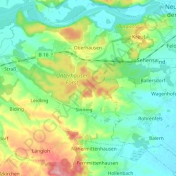
Name: Oberhausen topographic map, elevation, terrain.
Average elevation: 417 m
Minimum elevation: 379 m
Maximum elevation: 507 m
Other topographic maps
Click on a map to view its topography, its elevation and its terrain.
Schloss Sinning
Germany > Bavaria > Landkreis Neuburg-Schrobenhausen > Sinning
Average elevation: 432 m
Zell
Germany > Bavaria > Landkreis Neuburg-Schrobenhausen > Neuburg an der Donau
Average elevation: 379 m