Geolocate

Avellino topographic map

Click on the map to display elevation.

About this map

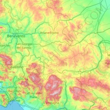
Name: Avellino topographic map, elevation, terrain.

Location: Avellino, Campania, Italy (40.70665 14.55946 41.28645 15.57231)

Average elevation: 533 m

Minimum elevation: 0 m

Maximum elevation: 1,802 m

Other topographic maps

Click on a map to view its topography, its elevation and its terrain.

Melito

Italy > Campania > Salerno > Prignano Cilento

Average elevation: 264 m

Monte Muto

Italy > Campania > Napoli > Gragnano

Average elevation: 444 m

Bagnoli

Italy > Campania > Benevento > Sant'Agata de' Goti

Average elevation: 203 m

Montepertuso

Italy > Campania > Salerno > Arienzo

Average elevation: 455 m

Naples

Italy > Campania > Napoli > Naples

In 1755, the Duke of Noja commissioned an accurate topographic map of Naples, later known as the Map of the Duke of Nojo, employing rigorous surveying accuracy and becoming an important urban planning tool for Naples.

Average elevation: 58 m

Gear up for your next adventure:

🥾Light Hiking Boots - Lightweight and comfortable boots for day hikes
🥾Mountain Trail Shoes - High-traction shoes for mountain trails
👟Leg Gaiters - Keep debris, mud, and snow out of your boots
🧢Hiking Sun Hat - Wide-brimmed protection for exposed mountain ridges
👟Sport Hiking Sandals - Breathable footwear for water crossings and camp rest

As an Amazon Associate, this site earns from qualifying purchases at no extra cost to you.