
Thiruvananthapuram topographic map
Interactive map
Click on the map to display elevation.
About this map
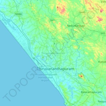
Name: Thiruvananthapuram topographic map, elevation, terrain.
Location: Thiruvananthapuram, Kerala, India (8.38681 76.79708 8.67428 77.04491)
Average elevation: 41 m
Minimum elevation: 0 m
Maximum elevation: 316 m
Other topographic maps
Click on a map to view its topography, its elevation and its terrain.
Kattimoola
India > Kerala > Mananthavady
Kattimoola, Mananthavady, Wayanad District, Kerala, 670644, India
Average elevation: 753 m
Thiruvananthapuram
India > Kerala > Thiruvananthapuram
Thiruvananthapuram, Kerala, 695001, India
Average elevation: 40 m
Perinkottukurushi
India > Kerala > Perinkottukurushi
Perinkottukurushi, Pālghāt, Palghat, Kerala, India
Average elevation: 61 m
Kunnamkulam
India > Kerala > Kunnamkulam
Kunnamkulam, Thrissur, Kerala, 680503, India
Average elevation: 11 m
Vadakkenchery
India > Kerala > Vadakkenchery
Vadakkenchery, Pālghāt, Palghat, Kerala, 678684, India
Average elevation: 62 m
Eravikulam National Park
Eravikulam National Park, Lakkomukudi, Idukki, Kerala, India
Average elevation: 1,702 m