
Make a donation
Gear up for your next adventure:
As an Amazon Associate, this site earns from qualifying purchases at no extra cost to you.
Rieti topographic map
Click on the map to display elevation.
Make a donation
Gear up for your next adventure:
As an Amazon Associate, this site earns from qualifying purchases at no extra cost to you.
Rieti
The province is largely mountainous with the Monti della Duchessa and the Monti del Cicolano ranges in the south with Monte Nuria and Monte Giano, the Monti Reatini range with Monte Terminillo (2217 m) in the north in part of the Abruzzese Apennines, and Monti della Laga (2458 m) to the east on the border with Abruzzo. Of particular importance are the two artificial lakes in the Valle del Salto: Lago del Salto and Lago del Turano, both created during the Fascist period. Lago del Salto is the largest in the Lazio region and is situated at an altitude of 1,755 metres (5,758 ft).
Make a donation
Gear up for your next adventure:
As an Amazon Associate, this site earns from qualifying purchases at no extra cost to you.
About this map
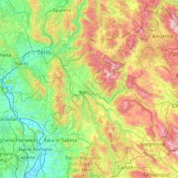
Name: Rieti topographic map, elevation, terrain.
Location: Rieti, Lazio, Italy (42.08892 12.43730 42.74097 13.40998)
Average elevation: 712 m
Minimum elevation: 20 m
Maximum elevation: 2,414 m
Make a donation
Gear up for your next adventure:
As an Amazon Associate, this site earns from qualifying purchases at no extra cost to you.