
Thank you for supporting this site ❤️
Make a donation
Make a donation
Gear up for your next adventure:
As an Amazon Associate, this site earns from qualifying purchases at no extra cost to you.
Simferopol topographic map
Click on the map to display elevation.
Thank you for supporting this site ❤️
Make a donation
Make a donation
Gear up for your next adventure:
As an Amazon Associate, this site earns from qualifying purchases at no extra cost to you.
About this map
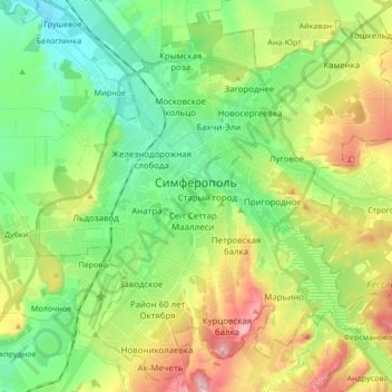
Name: Simferopol topographic map, elevation, terrain.
Location: Simferopol, Simferopol District, Republic of Crimea, Ukraine (44.89083 34.02892 45.00425 34.19892)
Average elevation: 295 m
Minimum elevation: 196 m
Maximum elevation: 481 m
Thank you for supporting this site ❤️
Make a donation
Make a donation
Gear up for your next adventure:
As an Amazon Associate, this site earns from qualifying purchases at no extra cost to you.
Other topographic maps
Click on a map to view its topography, its elevation and its terrain.
Rivnopillia
Ukraine > Republic of Crimea > Simferopol District > Кольчугинское сельское поселение
Average elevation: 64 m