
Make a donation
Gear up for your next adventure:
As an Amazon Associate, this site earns from qualifying purchases at no extra cost to you.
Tildonk topographic map
Click on the map to display elevation.
Make a donation
Gear up for your next adventure:
As an Amazon Associate, this site earns from qualifying purchases at no extra cost to you.
Tildonk
The name Tildonk is the joining of 2 medieval words: til (forest) and donk (elevation). During the 12th century the knights van Tildonk, pledged to the Duke of Brabant, lived in two mottes: Oudenborg and Nieuwenborg (where the current Kasteeltje is located). Tildonk was elevated to the title of county in 1699 as part of the fiefdom of Charles L'Archier. Later it came into the hands of the noble house of Lalaing. Count Maximilian de Lalaing was the most prominent de Lalaing lord of Tildonk.
Make a donation
Gear up for your next adventure:
As an Amazon Associate, this site earns from qualifying purchases at no extra cost to you.
About this map
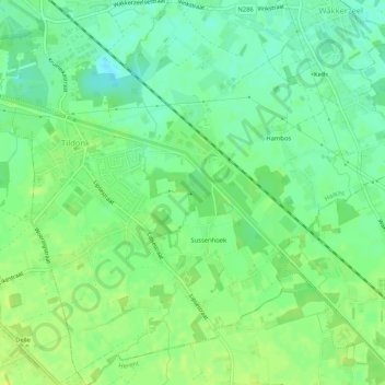
Name: Tildonk topographic map, elevation, terrain.
Location: Tildonk, Haacht, Leuven, Flemish Brabant, Flanders, Belgium (50.92452 4.63515 50.95724 4.68255)
Average elevation: 15 m
Minimum elevation: 5 m
Maximum elevation: 22 m
Make a donation
Gear up for your next adventure:
As an Amazon Associate, this site earns from qualifying purchases at no extra cost to you.