Geolocate

Garaioa topographic map

Click on the map to display elevation.

About this map

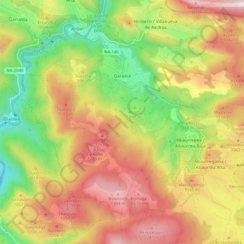
Name: Garaioa topographic map, elevation, terrain.

Location: Garaioa, Pirinioak / Pirineo, Navarre, Spain (42.88875 -1.28748 42.94355 -1.18700)

Average elevation: 983 m

Minimum elevation: 605 m

Maximum elevation: 1,369 m

Other topographic maps

Click on a map to view its topography, its elevation and its terrain.

Gernada

Spain > Navarre > Pirinioak / Pirineo > Erro > Aurizberri

Average elevation: 914 m

Gear up for your next adventure:

🧥Softshell Jacket - Windproof and breathable jacket for hiking
🕶️Polarized Sunglasses - Protect your eyes with durable polarized lenses
Lightweight Camping Tent - Portable shelter optimized for Canadian backcountry camping
🧢Hiking Hat - Sun-protective and breathable hats for long treks
💡Portable Camping Lamp - Rechargeable lamp for campsite lighting

As an Amazon Associate, this site earns from qualifying purchases at no extra cost to you.