
Thank you for supporting this site ❤️
Make a donation
Make a donation
Gear up for your next adventure:
As an Amazon Associate, this site earns from qualifying purchases at no extra cost to you.
Tewkesbury topographic map
Click on the map to display elevation.
Thank you for supporting this site ❤️
Make a donation
Make a donation
Gear up for your next adventure:
As an Amazon Associate, this site earns from qualifying purchases at no extra cost to you.
About this map
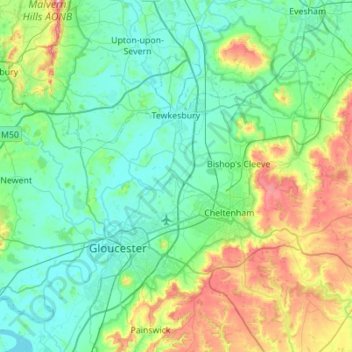
Name: Tewkesbury topographic map, elevation, terrain.
Location: Tewkesbury, Gloucestershire, England, United Kingdom (51.81930 -2.35275 52.05056 -1.80169)
Average elevation: 89 m
Minimum elevation: 2 m
Maximum elevation: 419 m
Thank you for supporting this site ❤️
Make a donation
Make a donation
Gear up for your next adventure:
As an Amazon Associate, this site earns from qualifying purchases at no extra cost to you.
Other topographic maps
Click on a map to view its topography, its elevation and its terrain.
Stow-on-the-Wold
United Kingdom > England > Gloucestershire > Cotswold District > Stow-on-the-Wold
Average elevation: 163 m