
Make a donation
Gear up for your next adventure:
As an Amazon Associate, this site earns from qualifying purchases at no extra cost to you.
Delligsen topographic map
Click on the map to display elevation.
Make a donation
Gear up for your next adventure:
As an Amazon Associate, this site earns from qualifying purchases at no extra cost to you.
Delligsen
Delligsen liegt im Leinebergland zwischen den Höhenzügen Reuberg im Norden, Steinberg im Nordosten, Selter im Südosten, Hils im Süden und Westen sowie Ith im Nordwesten. Durch den Ort fließt die Wispe als südwestlicher Zufluss der Leine.
Make a donation
Gear up for your next adventure:
As an Amazon Associate, this site earns from qualifying purchases at no extra cost to you.
About this map
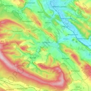
Name: Delligsen topographic map, elevation, terrain.
Location: Delligsen, Landkreis Holzminden, Niedersachsen, Deutschland (51.89561 9.71777 51.98294 9.89502)
Average elevation: 222 m
Minimum elevation: 86 m
Maximum elevation: 433 m
Make a donation
Gear up for your next adventure:
As an Amazon Associate, this site earns from qualifying purchases at no extra cost to you.
Other topographic maps
Click on a map to view its topography, its elevation and its terrain.