Geolocate

Distrito Sur topographic map

Click on the map to display elevation.

About this map

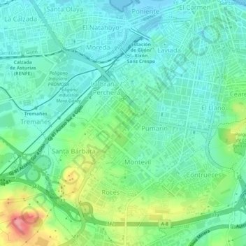
Name: Distrito Sur topographic map, elevation, terrain.

Location: Distrito Sur, Gijón, Asturias, Spain (43.51323 -5.70083 43.53986 -5.65609)

Average elevation: 28 m

Minimum elevation: -1 m

Maximum elevation: 103 m

Other topographic maps

Click on a map to view its topography, its elevation and its terrain.

Granda de Riba

Spain > Asturias > Gijón > Vega de Riba

Average elevation: 57 m

Gear up for your next adventure:

🎒Hiking Backpack - Lightweight and ergonomic backpacks for day hikes or multi-day treks
🥾Light Hiking Boots - Lightweight and comfortable boots for day hikes
🔥Camping Stove - Portable stoves to cook outdoors with ease
🧦Hiking Socks - Moisture-wicking and comfortable socks for long hikes
🥾Trekking Poles - Adjustable trekking poles to reduce knee stress and improve stability

As an Amazon Associate, this site earns from qualifying purchases at no extra cost to you.