
Make a donation
Gear up for your next adventure:
As an Amazon Associate, this site earns from qualifying purchases at no extra cost to you.
Ponta do Pargo topographic map
Click on the map to display elevation.
Make a donation
Gear up for your next adventure:
As an Amazon Associate, this site earns from qualifying purchases at no extra cost to you.
Ponta do Pargo
Ponta do Pargo is a diamond-shape territory on the western edge of the island Madeira. From its high-altitude cliffs it extends into the interior along escarpments cut by several river valleys to the Serra do Paul. The northwest to southwest border fronts the Atlantic Ocean, while its northern frontier is limited by its border with the municipality of Porto Moniz (Porto Moniz) and Fajã da Ovelha (within the municipality of Calheta. The cliff-top bluffs reach a height of 392 metres above sea level, while its interior extent reaches an altitude of just over 1321 metres. The most westerly extent, the Ponta in the parishes name, bears a lighthouse.
Make a donation
Gear up for your next adventure:
As an Amazon Associate, this site earns from qualifying purchases at no extra cost to you.
About this map
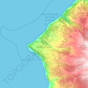
Name: Ponta do Pargo topographic map, elevation, terrain.
Location: Ponta do Pargo, Calheta, Madeira, Portugal (32.79068 -17.26593 32.84018 -17.17663)
Average elevation: 293 m
Minimum elevation: 0 m
Maximum elevation: 1,072 m
Make a donation
Gear up for your next adventure:
As an Amazon Associate, this site earns from qualifying purchases at no extra cost to you.