
Make a donation
Gear up for your next adventure:
As an Amazon Associate, this site earns from qualifying purchases at no extra cost to you.
Água Retorta topographic map
Click on the map to display elevation.
Make a donation
Gear up for your next adventure:
As an Amazon Associate, this site earns from qualifying purchases at no extra cost to you.
About this map
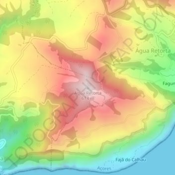
Name: Água Retorta topographic map, elevation, terrain.
Location: Água Retorta, Povoação, Açores, 9650-022, Portugal (37.75505 -25.17688 37.75515 -25.17678)
Average elevation: 339 m
Minimum elevation: 0 m
Maximum elevation: 666 m
Make a donation
Gear up for your next adventure:
As an Amazon Associate, this site earns from qualifying purchases at no extra cost to you.
Other topographic maps
Click on a map to view its topography, its elevation and its terrain.
Furnas
O clima nas Furnas, tal como nos Açores em geral, é fortemente influenciado pela presença constante da corrente quente do Golfo que dá origem a uma atmosfera quente e húmida, com frequente nebulosidade e pequena amplitude térmica anual. Por outro lado, a existência de superfícies frontais, devidas à…
Average elevation: 388 m