
Wychavon topographic map
Interactive map
Click on the map to display elevation.
About this map
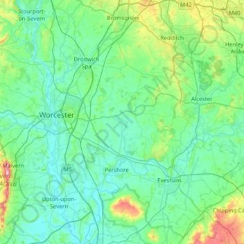
Name: Wychavon topographic map, elevation, terrain.
Average elevation: 68 m
Minimum elevation: 6 m
Maximum elevation: 418 m
Other topographic maps
Click on a map to view its topography, its elevation and its terrain.
Hill End
United Kingdom > England > Wychavon
Hill End, Wychavon, Worcestershire, West Midlands, England, WR9 8LJ, United Kingdom
Average elevation: 47 m