
Thank you for supporting this site ❤️
Make a donation
Make a donation
Gear up for your next adventure:
As an Amazon Associate, this site earns from qualifying purchases at no extra cost to you.
Eskifjörður topographic map
Click on the map to display elevation.
Thank you for supporting this site ❤️
Make a donation
Make a donation
Gear up for your next adventure:
As an Amazon Associate, this site earns from qualifying purchases at no extra cost to you.
About this map
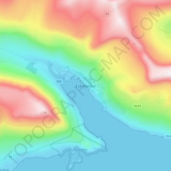
Name: Eskifjörður topographic map, elevation, terrain.
Location: Eskifjörður, Fjarðabyggð, Eastern Region, 735, Iceland (65.03131 -14.05237 65.11131 -13.97237)
Average elevation: 347 m
Minimum elevation: -4 m
Maximum elevation: 1,018 m
Thank you for supporting this site ❤️
Make a donation
Make a donation
Gear up for your next adventure:
As an Amazon Associate, this site earns from qualifying purchases at no extra cost to you.