
Make a donation
Gear up for your next adventure:
As an Amazon Associate, this site earns from qualifying purchases at no extra cost to you.
Sehnde topographic map
Click on the map to display elevation.
Make a donation
Gear up for your next adventure:
As an Amazon Associate, this site earns from qualifying purchases at no extra cost to you.
About this map
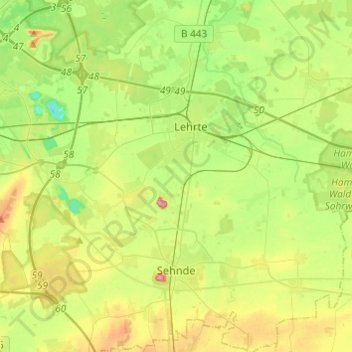
Name: Sehnde topographic map, elevation, terrain.
Location: Sehnde, Region Hannover, Niedersachsen, 31319, Deutschland (52.27990 9.86135 52.42812 10.08218)
Average elevation: 66 m
Minimum elevation: 20 m
Maximum elevation: 147 m
Make a donation
Gear up for your next adventure:
As an Amazon Associate, this site earns from qualifying purchases at no extra cost to you.
Other topographic maps
Click on a map to view its topography, its elevation and its terrain.
Bokeloh
Deutschland > Niedersachsen > Region Hannover > Wunstorf
Die weiß-graue Abraumhalde ist ein so genannter Kalimandscharo; eine Höhe von 140 Metern wurde genehmigt.
Average elevation: 51 m