Geolocate

Kumeū topographic map

Click on the map to display elevation.

About this map

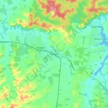
Name: Kumeū topographic map, elevation, terrain.

Location: Kumeū, Rodney, Auckland, 0810, New Zealand (-36.81531 174.51466 -36.73531 174.59466)

Average elevation: 48 m

Minimum elevation: 0 m

Maximum elevation: 157 m

Other topographic maps

Click on a map to view its topography, its elevation and its terrain.

Helensville

New Zealand > Auckland > Rodney

Average elevation: 21 m

Dome Forest

New Zealand > Auckland > Rodney

Average elevation: 168 m

Cowan Bay

New Zealand > Auckland > Rodney > Snells Beach

Average elevation: 22 m

Lake Rototoa

New Zealand > Auckland > Rodney

Average elevation: 102 m

Taupaki Estate

New Zealand > Auckland > Rodney > Kumeū

Average elevation: 37 m

Omaha Beach

New Zealand > Auckland > Rodney > Omaha

Average elevation: 3 m

Gear up for your next adventure:

🥾Waterproof Hiking Shoes - Durable shoes for wet and rugged trails
🔦LED Headtorch - Bright and durable light for night activities
🧼Travel Hand Sanitizer - Keep hands clean when water is scarce
🥾Waterproof Hiking Boots - Boots keeping your feet dry in wet conditions
💧Hydration Pack - Hands-free hydration system for long hikes

As an Amazon Associate, this site earns from qualifying purchases at no extra cost to you.