
Hartbeespoort Dam topographic map
Interactive map
Click on the map to display elevation.
About this map
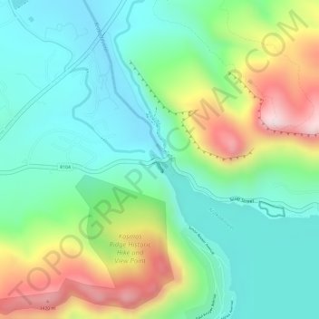
Name: Hartbeespoort Dam topographic map, elevation, terrain.
Average elevation: 1,253 m
Minimum elevation: 1,117 m
Maximum elevation: 1,509 m
Other topographic maps
Click on a map to view its topography, its elevation and its terrain.
Mmakau
South Africa > North West > Madibeng Local Municipality > Mmakau
Mmakau, Madibeng Local Municipality, Bojanala Platinum District Municipality, North West, 0194, South Africa
Average elevation: 1,246 m
KLIPVOOR DAM
South Africa > North West > Madibeng Local Municipality
KLIPVOOR DAM, Madibeng Ward 1, Madibeng Local Municipality, Bojanala Platinum District Municipality, North West, South Africa
Average elevation: 1,022 m