
Make a donation
Gear up for your next adventure:
As an Amazon Associate, this site earns from qualifying purchases at no extra cost to you.
West Palm Beach topographic map
Click on the map to display elevation.
Make a donation
Gear up for your next adventure:
As an Amazon Associate, this site earns from qualifying purchases at no extra cost to you.
West Palm Beach
Northwood Hills Historic District: On August 4, 2003, the City Commission designated the Northwood Hills neighborhood as the 13th Historic District in the City of West Palm Beach. Northwood Hills comprises the area from 29th Street on the South to 39th Court on the North. The east side of Windsor is the Western boundary, and Greenwood Avenue is the Eastern boundary. The Neighborhood Association has worked several years to achieve the distinction of historic designation. This is the first district to be designated since 1996. Northwood Hills has a number of Mission Revival houses, a significant collection of Post-World War II architecture, a unique street layout, and one of the highest elevations in the city. The Northwood Hills neighborhood has also elected to allow the establishment of Bed and Breakfast establishments within the neighborhood.
Make a donation
Gear up for your next adventure:
As an Amazon Associate, this site earns from qualifying purchases at no extra cost to you.
About this map
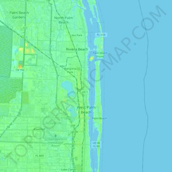
Name: West Palm Beach topographic map, elevation, terrain.
Location: West Palm Beach, Palm Beach County, Florida, United States (26.64442 -80.21463 26.84017 -80.04348)
Average elevation: 4 m
Minimum elevation: -2 m
Maximum elevation: 31 m
Make a donation
Gear up for your next adventure:
As an Amazon Associate, this site earns from qualifying purchases at no extra cost to you.
Other topographic maps
Click on a map to view its topography, its elevation and its terrain.
Make a donation
Gear up for your next adventure:
As an Amazon Associate, this site earns from qualifying purchases at no extra cost to you.
Make a donation
Gear up for your next adventure:
As an Amazon Associate, this site earns from qualifying purchases at no extra cost to you.
Make a donation
Gear up for your next adventure:
As an Amazon Associate, this site earns from qualifying purchases at no extra cost to you.
Make a donation
Gear up for your next adventure:
As an Amazon Associate, this site earns from qualifying purchases at no extra cost to you.
Delray Beach
United States > Florida > Palm Beach County > Delray Beach
Delray Beach has hot and humid summers. High summertime temperatures range from 87-93 °F with low temperatures around 75-78 °F. Winters are warm, with a marked drier season. Typical wintertime high temperatures are typically in the range of 74-83 °F and low temperatures 57-65 °F. However, when occasional…
Average elevation: 4 m
Villages of Oriole
United States > Florida > Palm Beach County > Villages of Oriole
Average elevation: 9 m
Make a donation
Gear up for your next adventure:
As an Amazon Associate, this site earns from qualifying purchases at no extra cost to you.
Blue Inlet
United States > Florida > Palm Beach County > Boca Raton > Blue Inlet
Average elevation: 4 m
Oslo national park
United States > Florida > Palm Beach County > West Palm Beach
Average elevation: 9 m
Make a donation
Gear up for your next adventure:
As an Amazon Associate, this site earns from qualifying purchases at no extra cost to you.