Geolocate

Islantilla topographic map

Click on the map to display elevation.

About this map

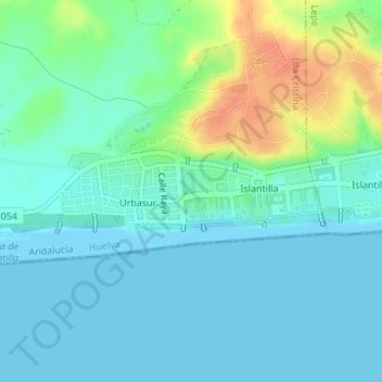
Name: Islantilla topographic map, elevation, terrain.

Location: Islantilla, Costa Occidental, Huelva, Andalucía, España (37.20383 -7.25438 37.20907 -7.23093)

Average elevation: 11 m

Minimum elevation: -2 m

Maximum elevation: 43 m

Gear up for your next adventure:

🏃Hydration Running Vest - Carry water and maps close to your body for speed
🥾Waterproof Hiking Boots - Essential footwear for rugged terrain and wet Canadian trails
🔥Camping Stove - Portable stoves to cook outdoors with ease
🧴Sunscreen SPF - Broad-spectrum sunscreen for outdoor activities
🧢Sun Protection Cap - Breathable cap to protect from sun exposure

As an Amazon Associate, this site earns from qualifying purchases at no extra cost to you.