Geolocate

Summit Township topographic map

Click on the map to display elevation.

About this map

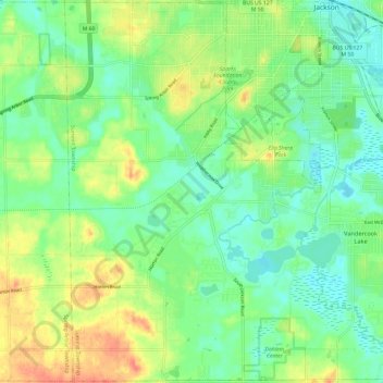
Name: Summit Township topographic map, elevation, terrain.

Location: Summit Township, Jackson County, Michigan, United States (42.16013 -84.48318 42.24755 -84.36421)

Average elevation: 300 m

Minimum elevation: 281 m

Maximum elevation: 331 m

Other topographic maps

Click on a map to view its topography, its elevation and its terrain.

Skiff Lake

United States > Michigan > Jackson County

Average elevation: 308 m

Honey Lake

United States > Michigan > Jackson County

Average elevation: 304 m

Olcott Lake

United States > Michigan > Jackson County

Average elevation: 289 m

Horton

United States > Michigan > Jackson County

Average elevation: 318 m

Leoni

United States > Michigan > Jackson County

Average elevation: 301 m

White Lake

United States > Michigan > Jackson County

Average elevation: 288 m

Gear up for your next adventure:

🛁Quick-Dry Microfiber Towel - Space-saving towel that dries rapidly on the move
🥫Freeze-Dried Meals - Lightweight, high-calorie nutrition for multi-day treks
🥾Trail Running Boots - Durable shoes designed for trail running
🔦LED Headlamp - Hands-free lighting for early morning starts or late finishes
🥾Waterproof Hiking Boots - Boots keeping your feet dry in wet conditions

As an Amazon Associate, this site earns from qualifying purchases at no extra cost to you.