
Make a donation
Gear up for your next adventure:
As an Amazon Associate, this site earns from qualifying purchases at no extra cost to you.
Hitzkofen topographic map
Click on the map to display elevation.
Make a donation
Gear up for your next adventure:
As an Amazon Associate, this site earns from qualifying purchases at no extra cost to you.
About this map
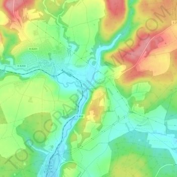
Name: Hitzkofen topographic map, elevation, terrain.
Average elevation: 631 m
Minimum elevation: 584 m
Maximum elevation: 698 m
Make a donation
Gear up for your next adventure:
As an Amazon Associate, this site earns from qualifying purchases at no extra cost to you.
Other topographic maps
Click on a map to view its topography, its elevation and its terrain.
Sigmaringen
Deutschland > Baden-Württemberg > Landkreis Sigmaringen
Sigmaringen bildet ein Mittelzentrum mit Teilfunktion eines Oberzentrums der Region Bodensee-Oberschwaben mit dem Oberzentrum Friedrichshafen-Ravensburg-Weingarten. Die offizielle Einwohnerzahl ist aber statisch nur bedingt aussagekräftig, da durch den relativ hohen Anteil an Auszubildenden, Studenten,…
Average elevation: 655 m
Bad Saulgau
Deutschland > Baden-Württemberg > Landkreis Sigmaringen
Bad Saulgau liegt nördlich des bewaldeten Höhenzugs Wagenhart und ein paar Kilometer westnordwestlich der Atzenberger Höhe, zwischen Donau und Bodensee am Donauzufluss Schwarzach. Durch den Ortsteil Lampertsweiler verläuft die Europäische Hauptwasserscheide, die das Einzugsgebiet von Rhein und Donau…
Average elevation: 613 m
Meßkirch
Deutschland > Baden-Württemberg > Landkreis Sigmaringen
Die Besiedlungsgeschichte des Meßkircher Raums reicht 3000 Jahre zurück. Die ältesten menschlichen Spuren auf Meßkircher Gemarkung stammen aus der Bronzezeit. Grabhügel im Bichtlinger Wald oder auf dem Dreibühl im Schnerkinger Wald zeigen, dass das Gebiet schon in der Hallstattzeit (um 9. bis 5.…
Average elevation: 667 m
Make a donation
Gear up for your next adventure:
As an Amazon Associate, this site earns from qualifying purchases at no extra cost to you.
Pfullendorf
Deutschland > Baden-Württemberg > Landkreis Sigmaringen
Die Stadt Pfullendorf liegt in topographischer Hanglage, rund 20 Kilometer nördlich des Bodensees im hügeligen Gelände des Linzgaus.
Average elevation: 654 m
Krauchenwies
Deutschland > Baden-Württemberg > Landkreis Sigmaringen
Die Gemeinde Krauchenwies liegt zwischen 568 und 685 m ü. NN am südlichen Rand des Naturparks Obere Donau. Die Gemarkungsfläche umfasst rund 4276 Hektar (Stand: 31. Dez. 2010). Der Ort Krauchenwies liegt rund zehn Kilometer südlich von Sigmaringen und circa 30 Kilometer nördlich des Bodensees.…
Average elevation: 623 m
Stetten am kalten Markt
Deutschland > Baden-Württemberg > Landkreis Sigmaringen
Die Gesamtgemeinde Stetten am kalten Markt liegt mit ihrer Gemarkungsfläche von 5637 Hektar (Stand: 30. Juni 2014) auf einer Höhenlage zwischen 640 und 866 Metern über dem Meeresspiegel. Die Gemeinde gehört zum ehemals badischen Teil des Heubergs und zum Naturpark Obere Donau. Durch den Stettener Ortsteil…
Average elevation: 775 m
Make a donation
Gear up for your next adventure:
As an Amazon Associate, this site earns from qualifying purchases at no extra cost to you.
Burg Ramsberg
Deutschland > Baden-Württemberg > Landkreis Sigmaringen > Großschönach
Heute befindet sich an der einstigen Burgstelle eine Einsiedelei. Die Burgkapelle stammt vermutlich noch aus romanischer Zeit. Die Kapelle geht im baulichen Bestand bis in die hochmittelalterliche Burganlage (11. Jahrhundert) der Grafen von Ramsberg und Pfullendorf zurück. Sie ist der Sockel des Bergfrieds,…
Average elevation: 635 m
Beuron
Deutschland > Baden-Württemberg > Landkreis Sigmaringen
Der gesamte Wald liegt im FFH-Gebiet Obere Donau, der Biotopanteil ist viermal höher als im Landesschnitt. Er ist Lebensraum für Rehe und Gämsen.
Average elevation: 795 m
Lauchert
Deutschland > Baden-Württemberg > Landkreis Sigmaringen
Liste der Zuflüsse und Seen von der Quelle des Willmandinger Oberlaufastes bis zur Mündung. Gewässerlänge, Seefläche, Einzugsgebiet und Höhe nach den entsprechenden Layern auf der Onlinekarte der LUBW. Andere Quellen für die Angaben sind vermerkt. Auswahl, ohne Mühl- und Triebwerkskanäle.
Average elevation: 736 m
Make a donation
Gear up for your next adventure:
As an Amazon Associate, this site earns from qualifying purchases at no extra cost to you.
Oberschmeien
Deutschland > Baden-Württemberg > Landkreis Sigmaringen > Sigmaringen
Oberschmeien liegt im Tal der namensgebenden Schmeie – der Ortskern zieht sich am linken Hangfuß entlang – im Naturpark Obere Donau. Am Hang darüber findet sich ein Neubaugebiet. Der Aussichtspunkt Fürstenhöhe bietet bei klarem Wetter einen Blick über Oberschwaben hinweg bis zu den Alpen. Auf der…
Average elevation: 712 m
72488
Deutschland > Baden-Württemberg > Landkreis Sigmaringen > Sigmaringen > Laiz
Average elevation: 652 m
88605
Deutschland > Baden-Württemberg > Landkreis Sigmaringen > Meßkirch > Schnerkingen
Average elevation: 628 m
Make a donation
Gear up for your next adventure:
As an Amazon Associate, this site earns from qualifying purchases at no extra cost to you.
Oberndorf (Herdwangen-Schönach)
Deutschland > Baden-Württemberg > Landkreis Sigmaringen > Herdwangen-Schönach
Oberndorf liegt auf einem Höhenzug des oberen Linzgau über dem Billafinger Tal. Der südwestlich von Herdwangen gelegene Teilort der Gemeinde Herdwangen-Schönach grenzt an Billafingen (Gemeinde Owingen) im Bodenseekreis, Mahlspüren im Tal (Stadt Stockach) und Kalkofen (Gemeinde Hohenfels) im Landkreis Konstanz.
Average elevation: 651 m
Heratskirch
Deutschland > Baden-Württemberg > Landkreis Sigmaringen > Bad Saulgau
Average elevation: 658 m
Make a donation
Gear up for your next adventure:
As an Amazon Associate, this site earns from qualifying purchases at no extra cost to you.
Veringenstadt
Deutschland > Baden-Württemberg > Landkreis Sigmaringen
Veringenstadt liegt im Tal der Lauchert, eines Nebenflusses der Donau, zwischen Gammertingen und Sigmaringen. Das Stadtgebiet erstreckt sich auf der Mittleren Flächenalb, in die sich etwa 100 m teils steilhängig das Laucherttal eingeschnitten hat, auf einer Höhe von 609 m bis 817 m. Die Gemeindefläche…
Average elevation: 725 m
Pfrunger-Burgweiler Ried
Deutschland > Baden-Württemberg > Landkreis Sigmaringen > Ostrach
Das heute rund 1015 Hektar große Naturschutzgebiet Pfrunger-Burgweiler Ried gehört naturräumlich zum Oberschwäbischen Hügelland. Es liegt etwa drei Kilometer südlich der Ostracher Ortsmitte und schließt unmittelbar nordwestlich an Wilhelmsdorf an. Es liegt auf einer Höhe von ungefähr 610 m ü. NHN und…
Average elevation: 639 m
Make a donation
Gear up for your next adventure:
As an Amazon Associate, this site earns from qualifying purchases at no extra cost to you.
88636
Deutschland > Baden-Württemberg > Landkreis Sigmaringen > Illmensee > Reute
Average elevation: 702 m
Scheer
Deutschland > Baden-Württemberg > Landkreis Sigmaringen
Von 536 bis 843 lag die Gemarkung von Scheer im Fränkischen Reich in der alamannischen Westbaar. Zu dieser Westbaar gehörten der Scherragau, der Eritgau und der Linzgau. Scheer war vermutlich der Hauptort des Scherragaus. Es folgte nach 843 die Zeit des Ostfränkischen Reiches und des Stammesherzogtums…
Average elevation: 603 m
88512
Deutschland > Baden-Württemberg > Landkreis Sigmaringen > Mengen > Ennetach
Average elevation: 597 m
Levertsweiler
Deutschland > Baden-Württemberg > Landkreis Sigmaringen > Ostrach
Average elevation: 624 m
Make a donation
Gear up for your next adventure:
As an Amazon Associate, this site earns from qualifying purchases at no extra cost to you.
Engelswies
Deutschland > Baden-Württemberg > Landkreis Sigmaringen
Engelswies gehört zusammen mit Vilsingen zu den am frühesten erwähnten Orten in der Region. Sie wurden erstmals im Frühmittelalter in einer ins Jahr 793 datierten Urkunde im St. Gallener Urkundenbuch notiert. Ein Peratoldus machte eine große Schenkung an das Kloster St. Gallen, unter anderem auch Güter…
Average elevation: 664 m
Leibertingen
Deutschland > Baden-Württemberg > Landkreis Sigmaringen
Leibertingen liegt in 600 bis 850 Meter Höhe direkt über dem Donautal auf dem Badischen Heuberg am Südrand der Schwäbischen Alb, etwa 22 Kilometer von der Kreisstadt Sigmaringen und 24 Kilometer von Tuttlingen entfernt. Von der Gemarkungsfläche von rund 4720 Hektar (Stand: 31. Dezember 2010) sind 2127…
Average elevation: 753 m
Veringendorf
Deutschland > Baden-Württemberg > Landkreis Sigmaringen
Veringenstadt liegt im Tal der Lauchert, eines Nebenflusses der Donau, zwischen Gammertingen und Sigmaringen. Das Stadtgebiet erstreckt sich auf der Mittleren Flächenalb, in die sich etwa 100 m teils steilhängig das Laucherttal eingeschnitten hat, auf einer Höhe von 609 m bis 817 m. Die Gemeindefläche…
Average elevation: 706 m
Make a donation
Gear up for your next adventure:
As an Amazon Associate, this site earns from qualifying purchases at no extra cost to you.
Gutenstein
Deutschland > Baden-Württemberg > Landkreis Sigmaringen > Sigmaringen
Average elevation: 677 m
Lampertsweiler
Deutschland > Baden-Württemberg > Landkreis Sigmaringen > Bad Saulgau
Average elevation: 617 m
Make a donation
Gear up for your next adventure:
As an Amazon Associate, this site earns from qualifying purchases at no extra cost to you.
Frohnstetten
Deutschland > Baden-Württemberg > Landkreis Sigmaringen > Stetten am kalten Markt
Average elevation: 807 m
Hettingen
Deutschland > Baden-Württemberg > Landkreis Sigmaringen
Hettingen liegt im Südwesten der Schwäbischen Alb. Der Stadtteil Hettingen liegt im Tal der Lauchert in 630 bis 795 Meter Höhe. Der größere Stadtteil Inneringen liegt auf der Albhochfläche, der Signalstein „auf der Eck“ liegt bei 818,96 m ü. NN. Die Gemarkungsfläche umfasst rund 4606 Hektar (Stand:…
Average elevation: 742 m
Mengen
Deutschland > Baden-Württemberg > Landkreis Sigmaringen
Die Bürgerwache Mengen ist ein Traditionsverein. Ihren Ursprung hat die Bürgerwache mit der Stadterhebung im Jahre 1276, als jeder Bürger verpflichtet wurde, bei den Wehranlagen mitzubauen und für Schutz und Verteidigung gegen Belagerungen und Plünderungen zu sorgen. Nach dem Dreißigjährigen Krieg…
Average elevation: 594 m
Make a donation
Gear up for your next adventure:
As an Amazon Associate, this site earns from qualifying purchases at no extra cost to you.
Hohentengen
Deutschland > Baden-Württemberg > Landkreis Sigmaringen
Hohentengen liegt etwa 20 Kilometer südöstlich von Sigmaringen in einer eiszeitlichen Endmoränenlandschaft auf einer Höhe von 594 m ü. NN. Der Landschafts- und Verwaltungsraum, dessen Hauptort Hohentengen ist, wird Göge genannt. Die Gemarkungsfläche umfasst rund 3657 Hektar (Stand: 31. Dezember 2010).
Average elevation: 589 m
Make a donation
Gear up for your next adventure:
As an Amazon Associate, this site earns from qualifying purchases at no extra cost to you.
Bad Saulgau
Deutschland > Baden-Württemberg > Landkreis Sigmaringen
Bad Saulgau liegt nördlich des bewaldeten Höhenzugs Wagenhart und ein paar Kilometer westnordwestlich der Atzenberger Höhe, zwischen Donau und Bodensee am Donauzufluss Schwarzach. Durch den Ortsteil Lampertsweiler verläuft die Europäische Hauptwasserscheide, die das Einzugsgebiet von Rhein und Donau…
Average elevation: 613 m
Gutenstein
Deutschland > Baden-Württemberg > Landkreis Sigmaringen > Sigmaringen
Average elevation: 677 m
Engelswies
Deutschland > Baden-Württemberg > Landkreis Sigmaringen
Engelswies gehört zusammen mit Vilsingen zu den am frühesten erwähnten Orten in der Region. Sie wurden erstmals im Frühmittelalter in einer ins Jahr 793 datierten Urkunde im St. Gallener Urkundenbuch notiert. Ein Peratoldus machte eine große Schenkung an das Kloster St. Gallen, unter anderem auch Güter…
Average elevation: 664 m
88512
Deutschland > Baden-Württemberg > Landkreis Sigmaringen > Mengen > Ennetach
Average elevation: 597 m
Make a donation
Gear up for your next adventure:
As an Amazon Associate, this site earns from qualifying purchases at no extra cost to you.
Pfullendorf
Deutschland > Baden-Württemberg > Landkreis Sigmaringen
Die Stadt Pfullendorf liegt in topographischer Hanglage, rund 20 Kilometer nördlich des Bodensees im hügeligen Gelände des Linzgaus.
Average elevation: 654 m
Mengen
Deutschland > Baden-Württemberg > Landkreis Sigmaringen
Die Bürgerwache Mengen ist ein Traditionsverein. Ihren Ursprung hat die Bürgerwache mit der Stadterhebung im Jahre 1276, als jeder Bürger verpflichtet wurde, bei den Wehranlagen mitzubauen und für Schutz und Verteidigung gegen Belagerungen und Plünderungen zu sorgen. Nach dem Dreißigjährigen Krieg…
Average elevation: 594 m
Sigmaringen
Deutschland > Baden-Württemberg > Landkreis Sigmaringen
Sigmaringen bildet ein Mittelzentrum mit Teilfunktion eines Oberzentrums der Region Bodensee-Oberschwaben mit dem Oberzentrum Friedrichshafen-Ravensburg-Weingarten. Die offizielle Einwohnerzahl ist aber statisch nur bedingt aussagekräftig, da durch den relativ hohen Anteil an Auszubildenden, Studenten,…
Average elevation: 655 m
Make a donation
Gear up for your next adventure:
As an Amazon Associate, this site earns from qualifying purchases at no extra cost to you.