
Make a donation
Gear up for your next adventure:
As an Amazon Associate, this site earns from qualifying purchases at no extra cost to you.
Circuata topographic map
Click on the map to display elevation.
Make a donation
Gear up for your next adventure:
As an Amazon Associate, this site earns from qualifying purchases at no extra cost to you.
About this map
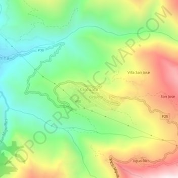
Name: Circuata topographic map, elevation, terrain.
Average elevation: 1,805 m
Minimum elevation: 1,387 m
Maximum elevation: 2,414 m
Make a donation
Gear up for your next adventure:
As an Amazon Associate, this site earns from qualifying purchases at no extra cost to you.
Other topographic maps
Click on a map to view its topography, its elevation and its terrain.
Cajuata
Bolivia > La Paz > Provincia Inquisivi > Municipio Cajuata
El municipio de Cajuata se encuentra ubicado al sureste del Departamento de La Paz, geográficamente está ubicado a los 16º 31’ 10” Latitud Sud y 67º 08’ 32” y 67º 20’ 15” Longitud Oeste y se encuentra a una altitud de 1682 m.s.n.m.
Average elevation: 1,704 m