
Make a donation
Gear up for your next adventure:
As an Amazon Associate, this site earns from qualifying purchases at no extra cost to you.
Whitehall topographic map
Click on the map to display elevation.
Make a donation
Gear up for your next adventure:
As an Amazon Associate, this site earns from qualifying purchases at no extra cost to you.
About this map
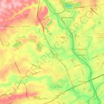
Name: Whitehall topographic map, elevation, terrain.
Location: Whitehall, Lehigh County, Pennsylvania, United States (40.61237 -75.54718 40.70223 -75.45954)
Average elevation: 122 m
Minimum elevation: 15 m
Maximum elevation: 217 m
Make a donation
Gear up for your next adventure:
As an Amazon Associate, this site earns from qualifying purchases at no extra cost to you.
Other topographic maps
Click on a map to view its topography, its elevation and its terrain.
Hensingersville
United States > Pennsylvania > Lehigh County > Lower Macungie Township
Average elevation: 203 m
Bake Oven Knob
United States > Pennsylvania > Lehigh County > Heidelberg Township
Average elevation: 310 m
Walbert
United States > Pennsylvania > Lehigh County > South Whitehall Township
Average elevation: 137 m
Make a donation
Gear up for your next adventure:
As an Amazon Associate, this site earns from qualifying purchases at no extra cost to you.
Laurys Station
United States > Pennsylvania > Lehigh County > North Whitehall Township
Average elevation: 152 m
Neffs
United States > Pennsylvania > Lehigh County > North Whitehall Township
Average elevation: 208 m
Make a donation
Gear up for your next adventure:
As an Amazon Associate, this site earns from qualifying purchases at no extra cost to you.
Crackersport
United States > Pennsylvania > Lehigh County > South Whitehall Township
Average elevation: 138 m
Metamora Station
United States > Pennsylvania > Lehigh County > South Whitehall Township > Metamora Station
Average elevation: 125 m
Old Zionsville
United States > Pennsylvania > Lehigh County > Upper Milford Township
Average elevation: 217 m
Milford Park
United States > Pennsylvania > Lehigh County > Upper Milford Township
Average elevation: 221 m
Make a donation
Gear up for your next adventure:
As an Amazon Associate, this site earns from qualifying purchases at no extra cost to you.