Geolocate

Santa Monica topographic map

Click on the map to display elevation.

About this map

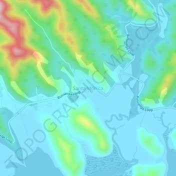
Name: Santa Monica topographic map, elevation, terrain.

Location: Santa Monica, Coron, Palawan, Mimaropa, Philippines (12.02565 120.12395 12.06565 120.16395)

Average elevation: 58 m

Minimum elevation: -1 m

Maximum elevation: 304 m

Other topographic maps

Click on a map to view its topography, its elevation and its terrain.

Apo Island

Philippines > Palawan > Coron

Average elevation: 22 m

Mayanpayan Island

Philippines > Palawan > Coron

Average elevation: 7 m

Coron Island

Philippines > Palawan > Coron

Average elevation: 37 m

Bulalacao

Philippines > Palawan > Coron

Average elevation: 3 m

Bulalacao

Philippines > Palawan > Coron

Average elevation: 3 m

Pedrasa Island

Philippines > Palawan > Coron

Average elevation: 18 m

Gear up for your next adventure:

🧭GPS Handheld Device - Reliable GPS navigation for outdoor adventures
🧢Hiking Sun Hat - Wide-brimmed protection for exposed mountain ridges
🥾Mountain Hiking Shoes - Shoes with superior grip for mountainous terrain
🕶️Polarized Sunglasses - Protect your eyes with durable polarized lenses
🛌Down Sleeping Bag - Superior warmth-to-weight ratio for cold nights

As an Amazon Associate, this site earns from qualifying purchases at no extra cost to you.