
Thank you for supporting this site ❤️
Make a donation
Make a donation
Gear up for your next adventure:
As an Amazon Associate, this site earns from qualifying purchases at no extra cost to you.
Hoher Mechtin topographic map
Click on the map to display elevation.
Thank you for supporting this site ❤️
Make a donation
Make a donation
Gear up for your next adventure:
As an Amazon Associate, this site earns from qualifying purchases at no extra cost to you.
Hoher Mechtin
Lage des Hohen Mechtin im Drawehn; Darstellung u. a. mit Höhenschichten hellgrün (Bereiche unter 20 m), orange-rot (50–75 m), dunkelbraun (über 100 m)
Thank you for supporting this site ❤️
Make a donation
Make a donation
Gear up for your next adventure:
As an Amazon Associate, this site earns from qualifying purchases at no extra cost to you.
About this map
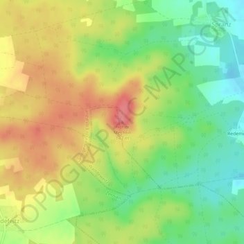
Name: Hoher Mechtin topographic map, elevation, terrain.
Average elevation: 101 m
Minimum elevation: 62 m
Maximum elevation: 142 m
Thank you for supporting this site ❤️
Make a donation
Make a donation
Gear up for your next adventure:
As an Amazon Associate, this site earns from qualifying purchases at no extra cost to you.