Geolocate

Langenhagen topographic map

Click on the map to display elevation.

About this map

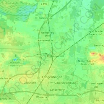
Name: Langenhagen topographic map, elevation, terrain.

Location: Langenhagen, Region Hannover, Lower Saxony, Germany (52.42285 9.62885 52.50638 9.77664)

Average elevation: 51 m

Minimum elevation: 38 m

Maximum elevation: 72 m

Other topographic maps

Click on a map to view its topography, its elevation and its terrain.

Scherenbostel

Germany > Lower Saxony > Region Hannover

Average elevation: 60 m

Altwarmbüchen

Germany > Lower Saxony > Region Hannover

Average elevation: 57 m

Dachtmissen

Germany > Lower Saxony > Region Hannover > Burgdorf

Average elevation: 53 m

Resse

Germany > Lower Saxony > Region Hannover

Average elevation: 48 m

Kirchhorst

Germany > Lower Saxony > Region Hannover

Average elevation: 60 m

Liethe

Germany > Lower Saxony > Region Hannover > Wunstorf

Average elevation: 46 m

Gear up for your next adventure:

🦶Hiking Shoe Insoles - Added support for high arches and long days on feet
🧢Sun Hat - Wide-brim hat for sun protection
🧰Emergency Multi-Tool - Compact multi-tool for outdoor survival
🧶550 Survival Paracord - Versatile utility cord for emergency repairs and rigging
🧥Ultralight Puffy Jacket - Maximum warmth that packs down to the size of an orange

As an Amazon Associate, this site earns from qualifying purchases at no extra cost to you.