
Make a donation
Gear up for your next adventure:
As an Amazon Associate, this site earns from qualifying purchases at no extra cost to you.
Bossolasco topographic map
Click on the map to display elevation.
Make a donation
Gear up for your next adventure:
As an Amazon Associate, this site earns from qualifying purchases at no extra cost to you.
Bossolasco
Bossolasco liegt 52 km von der Provinzhauptstadt Cuneo, erhöht auf einem Hügel, mit einer Höhe von 757 m s.l.m. in der Weinregion Langhe. Das Gemeindegebiet umfasst eine Fläche von 14,35 km² und hat 660 Einwohner (Stand 31. Dezember 2024). Zur Gemeinde zählt auch die Fraktion (Frazioni) Bossolaschetto. Bossolasco ist Teil der Bergkommune Comunità Montana Alta Langa. Bei Bossolasco wird in beschränktem maße Weinbau betrieben. Die Beeren der Rebsorten Spätburgunder und/oder Chardonnay dürfen zum Schaumwein Alta Langa verarbeitet werden.
Make a donation
Gear up for your next adventure:
As an Amazon Associate, this site earns from qualifying purchases at no extra cost to you.
About this map
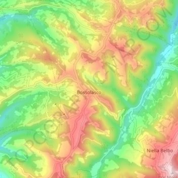
Name: Bossolasco topographic map, elevation, terrain.
Location: Bossolasco, Cuneo, Piemont, Italien (44.50486 8.01579 44.55566 8.08456)
Average elevation: 648 m
Minimum elevation: 467 m
Maximum elevation: 868 m
Make a donation
Gear up for your next adventure:
As an Amazon Associate, this site earns from qualifying purchases at no extra cost to you.
Other topographic maps
Click on a map to view its topography, its elevation and its terrain.
Make a donation
Gear up for your next adventure:
As an Amazon Associate, this site earns from qualifying purchases at no extra cost to you.
Make a donation
Gear up for your next adventure:
As an Amazon Associate, this site earns from qualifying purchases at no extra cost to you.
Monviso
Italien > Piemont > Cuneo > Pontechianale
Den Normalweg, der über die Südseite auf den Gipfel führt, erreicht man von Osten (Italien) vom Ausgangsort Crissolo im oberen Po-Tal über die Hütten Pian del Re und Quintino Sella am See Lago Grande di Viso (2640 m). Von Westen (Frankreich) erreicht man den Normalweg über die Hütte Rifugio Vallanta.…
Average elevation: 2,985 m
Make a donation
Gear up for your next adventure:
As an Amazon Associate, this site earns from qualifying purchases at no extra cost to you.
Make a donation
Gear up for your next adventure:
As an Amazon Associate, this site earns from qualifying purchases at no extra cost to you.