Geolocate

Hope River topographic map

Click on the map to display elevation.

About this map

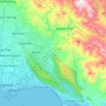
Name: Hope River topographic map, elevation, terrain.

Location: Hope River, Kingston, Surrey County, 7, Jamaica (17.94665 -76.74006 18.06927 -76.70401)

Average elevation: 383 m

Minimum elevation: 0 m

Maximum elevation: 1,391 m

Other topographic maps

Click on a map to view its topography, its elevation and its terrain.

Rockfort

Jamaica > Kingston > Kingston

Average elevation: 126 m

Gear up for your next adventure:

Lightweight Camping Tent - Portable shelter optimized for Canadian backcountry camping
🥾Hiking Boots - Sturdy boots providing ankle support and traction on rugged trails
🪜Heavy Duty Carabiners - Multi-use clips for securing gear to your backpack
🥾Mountain Hiking Boots - High-traction boots for rocky terrain
👖Convertible Hiking Pants - Zip-off legs to adapt to changing weather conditions

As an Amazon Associate, this site earns from qualifying purchases at no extra cost to you.