Geolocate

Pedregal topographic map

Click on the map to display elevation.

About this map

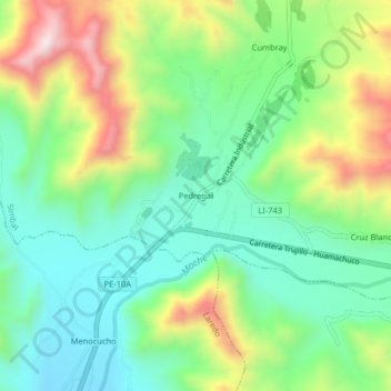
Name: Pedregal topographic map, elevation, terrain.

Location: Pedregal, Simbal, Trujillo, La Libertad, Perú (-8.02878 -78.84812 -7.98878 -78.80812)

Average elevation: 473 m

Minimum elevation: 290 m

Maximum elevation: 820 m

Gear up for your next adventure:

🧢Sun Protection Cap - Breathable cap to protect from sun exposure
🧥Softshell Jacket - Windproof and breathable jacket for hiking
🧢Outdoor Visor - Breathable visor for sunny hikes
🥽Outdoor Goggles - Protective eyewear for outdoor activities
👖Convertible Hiking Pants - Zip-off legs to adapt to changing weather conditions

As an Amazon Associate, this site earns from qualifying purchases at no extra cost to you.