Geolocate

Emerson topographic map

Click on the map to display elevation.

About this map

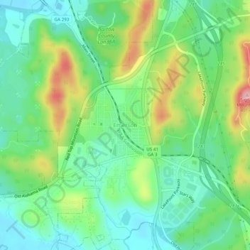
Name: Emerson topographic map, elevation, terrain.

Location: Emerson, Bartow County, Georgia, 30137, United States (34.10704 -84.77549 34.14704 -84.73549)

Average elevation: 266 m

Minimum elevation: 206 m

Maximum elevation: 387 m

Gear up for your next adventure:

Backpacking Tent - Lightweight tent for long-distance hiking trips
💡Compact LED Flashlight - Powerful and portable flashlight for outdoor use
💧Filtered Water Bottle - Safe drinking water on the go
🥾Waterproof Trail Shoes - Shoes designed to handle wet terrain
🧣Evaporative Cooling Towel - Beat the heat during intense summer climbs

As an Amazon Associate, this site earns from qualifying purchases at no extra cost to you.