
Make a donation
Gear up for your next adventure:
As an Amazon Associate, this site earns from qualifying purchases at no extra cost to you.
Stöcken topographic map
Click on the map to display elevation.
Make a donation
Gear up for your next adventure:
As an Amazon Associate, this site earns from qualifying purchases at no extra cost to you.
Stöcken
Stadtteile Agger | Albach | Algert | Birk | Breidt | Dahlhaus | Deesem | Donrath | Durbusch | Ellhausen | Geber | Grimberg | Hausen | Heide | Heppenberg | Höffen | Honrath | Hove | Hoven | Inger | Krahwinkel | Lohmar | Muchensiefen | Münchhof | Neuhonrath | Oberstehöhe | Scheid | Scheiderhöhe | Wahlscheid | Weegen | Wielpütz
Make a donation
Gear up for your next adventure:
As an Amazon Associate, this site earns from qualifying purchases at no extra cost to you.
About this map
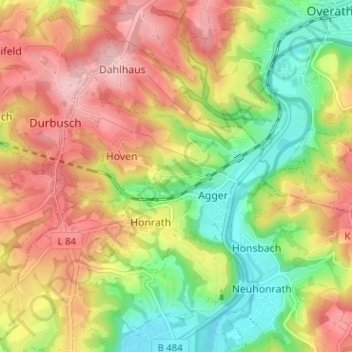
Name: Stöcken topographic map, elevation, terrain.
Average elevation: 156 m
Minimum elevation: 73 m
Maximum elevation: 237 m
Make a donation
Gear up for your next adventure:
As an Amazon Associate, this site earns from qualifying purchases at no extra cost to you.