
Thank you for supporting this site ❤️
Make a donation
Make a donation
Gear up for your next adventure:
As an Amazon Associate, this site earns from qualifying purchases at no extra cost to you.
Astorga topographic map
Click on the map to display elevation.
Thank you for supporting this site ❤️
Make a donation
Make a donation
Gear up for your next adventure:
As an Amazon Associate, this site earns from qualifying purchases at no extra cost to you.
Astorga
Astorga est située dans le nord-ouest de l'Espagne, sur un plateau, la Meseta, à une altitude de 850 m.
Thank you for supporting this site ❤️
Make a donation
Make a donation
Gear up for your next adventure:
As an Amazon Associate, this site earns from qualifying purchases at no extra cost to you.
About this map
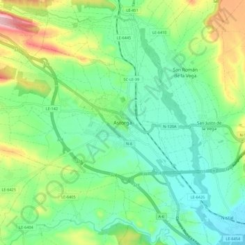
Name: Astorga topographic map, elevation, terrain.
Location: Astorga, León, Castille-et-León, 24700, Espagne (42.41536 -6.09290 42.49536 -6.01290)
Average elevation: 873 m
Minimum elevation: 817 m
Maximum elevation: 999 m
Thank you for supporting this site ❤️
Make a donation
Make a donation
Gear up for your next adventure:
As an Amazon Associate, this site earns from qualifying purchases at no extra cost to you.