
Make a donation
Gear up for your next adventure:
As an Amazon Associate, this site earns from qualifying purchases at no extra cost to you.
Bessemer City topographic map
Click on the map to display elevation.
Make a donation
Gear up for your next adventure:
As an Amazon Associate, this site earns from qualifying purchases at no extra cost to you.
Bessemer City
According to the United States Census Bureau, the city has a total area of 4.8 square miles (12.5 km2), of which 4.8 square miles (12.4 km2) is land and 0.039 square miles (0.1 km2), or 0.78%, is water. The elevation at city hall is 904 feet (276 m) above sea level.
Make a donation
Gear up for your next adventure:
As an Amazon Associate, this site earns from qualifying purchases at no extra cost to you.
About this map
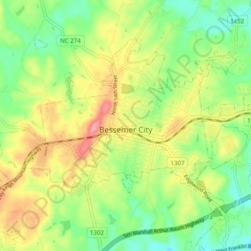
Name: Bessemer City topographic map, elevation, terrain.
Location: Bessemer City, Gaston County, North Carolina, United States (35.26560 -81.32015 35.30563 -81.25000)
Average elevation: 258 m
Minimum elevation: 215 m
Maximum elevation: 315 m
Make a donation
Gear up for your next adventure:
As an Amazon Associate, this site earns from qualifying purchases at no extra cost to you.
Other topographic maps
Click on a map to view its topography, its elevation and its terrain.
Make a donation
Gear up for your next adventure:
As an Amazon Associate, this site earns from qualifying purchases at no extra cost to you.