Geolocate

Morrilton topographic map

Click on the map to display elevation.

About this map

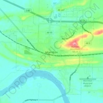
Name: Morrilton topographic map, elevation, terrain.

Location: Morrilton, Conway County, Arkansas, 72110, United States (35.12630 -92.78421 35.18291 -92.70120)

Average elevation: 103 m

Minimum elevation: 79 m

Maximum elevation: 190 m

Other topographic maps

Click on a map to view its topography, its elevation and its terrain.

Lost Corner

United States > Arkansas > Conway County

Average elevation: 172 m

Center Ridge

United States > Arkansas > Conway County

Average elevation: 211 m

Springfield

United States > Arkansas > Conway County

Average elevation: 140 m

Hill Creek

United States > Arkansas > Conway County

Average elevation: 107 m

Brewer Lake

United States > Arkansas > Conway County

Average elevation: 115 m

Gear up for your next adventure:

🥾Trail Hiking Socks - Comfortable socks to prevent blisters and fatigue
🧭Orienteering Kit - Tools for map reading and navigation in the wild
🥾Trail Hiking Boots - Supportive boots for rough trails
🥫Freeze-Dried Meals - Lightweight, high-calorie nutrition for multi-day treks
🪑Ultralight Camping Stool - Compact seating for rest stops during long hikes

As an Amazon Associate, this site earns from qualifying purchases at no extra cost to you.