
Thank you for supporting this site ❤️
Make a donation
Make a donation
Gear up for your next adventure:
As an Amazon Associate, this site earns from qualifying purchases at no extra cost to you.
Bras-Fusil topographic map
Click on the map to display elevation.
Thank you for supporting this site ❤️
Make a donation
Make a donation
Gear up for your next adventure:
As an Amazon Associate, this site earns from qualifying purchases at no extra cost to you.
About this map
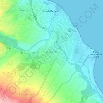
Name: Bras-Fusil topographic map, elevation, terrain.
Location: Bras-Fusil, Saint-Benoît, La Réunion, 97470, France (-21.06898 55.69349 -21.02898 55.73349)
Average elevation: 47 m
Minimum elevation: 0 m
Maximum elevation: 189 m
Thank you for supporting this site ❤️
Make a donation
Make a donation
Gear up for your next adventure:
As an Amazon Associate, this site earns from qualifying purchases at no extra cost to you.