
Make a donation
Gear up for your next adventure:
As an Amazon Associate, this site earns from qualifying purchases at no extra cost to you.
Schüttorf topographic map
Click on the map to display elevation.
Make a donation
Gear up for your next adventure:
As an Amazon Associate, this site earns from qualifying purchases at no extra cost to you.
Schüttorf
The town of Schüttorf lies mainly on valley sand plates which are crossed by the Vechte Lowland, which is almost flush with them along this stretch. The lowland lies roughly 30 m above sea level and is from 200 to 500 m wide. Bordering its edges are river terraces with a height of roughly 35 m above sea level. Owing to the slight difference in elevation even within the river valley, the middle Vechte meandered in the past, leading to the formation of many backwaters. Since then, however, the river has been straightened and is kept at Schüttorf level.
Make a donation
Gear up for your next adventure:
As an Amazon Associate, this site earns from qualifying purchases at no extra cost to you.
About this map
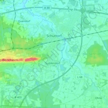
Name: Schüttorf topographic map, elevation, terrain.
Average elevation: 39 m
Minimum elevation: 28 m
Maximum elevation: 89 m
Make a donation
Gear up for your next adventure:
As an Amazon Associate, this site earns from qualifying purchases at no extra cost to you.
Other topographic maps
Click on a map to view its topography, its elevation and its terrain.
Hagelshoek
Germany > Lower Saxony > Landkreis Grafschaft Bentheim > Bad Bentheim > Gildehaus
Average elevation: 48 m