
Make a donation
Gear up for your next adventure:
As an Amazon Associate, this site earns from qualifying purchases at no extra cost to you.
Staten Island topographic map
Click on the map to display elevation.
Make a donation
Gear up for your next adventure:
As an Amazon Associate, this site earns from qualifying purchases at no extra cost to you.
Staten Island
Temperatures are low year round but without extreme minimum temperatures. The mean temperature in summer is 8.3 °C (46.9 °F) with mean extremes of 16.2 °C (61.2 °F) and 3.0 °C (37.4 °F) while in winter, the mean temperature is 3.3 °C (37.9 °F) with mean extremes of 7.7 °C (45.9 °F) and −4 °C (24.8 °F). Mean temperatures are lower than in Tierra del Fuego but due to the moderating influence of the ocean, extreme minimum temperatures are higher than in Tierra del Fuego. Coastal areas have average temperatures above 0 °C (32.0 °F) in the coldest month while higher altitude locations may average below 0 °C (32.0 °F).
Make a donation
Gear up for your next adventure:
As an Amazon Associate, this site earns from qualifying purchases at no extra cost to you.
About this map
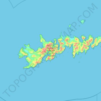
Name: Staten Island topographic map, elevation, terrain.
Average elevation: 23 m
Minimum elevation: -1 m
Maximum elevation: 775 m
Make a donation
Gear up for your next adventure:
As an Amazon Associate, this site earns from qualifying purchases at no extra cost to you.