
Make a donation
Gear up for your next adventure:
As an Amazon Associate, this site earns from qualifying purchases at no extra cost to you.
Wallhöfen topographic map
Click on the map to display elevation.
Make a donation
Gear up for your next adventure:
As an Amazon Associate, this site earns from qualifying purchases at no extra cost to you.
About this map
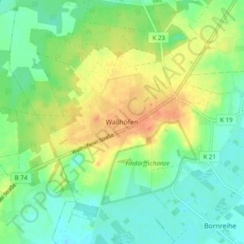
Name: Wallhöfen topographic map, elevation, terrain.
Average elevation: 20 m
Minimum elevation: 2 m
Maximum elevation: 46 m
Make a donation
Gear up for your next adventure:
As an Amazon Associate, this site earns from qualifying purchases at no extra cost to you.
Other topographic maps
Click on a map to view its topography, its elevation and its terrain.
Lilienthal
Deutschland > Niedersachsen > Landkreis Osterholz
Der Windpark Oberende wurde von der spanischen Firma Gamesa errichtet und 2009 in Betrieb genommen. Die fünf Windkraftanlagen sind vom Typ Gamesa G 58 und haben eine Gesamthöhe von 100 Meter. Die Leistung jeder Anlage wird mit 850 kW angegeben. Alle Anlagen wurden 2010 an IKEA veräußert.
Average elevation: 4 m