
Thank you for supporting this site ❤️
Make a donation
Make a donation
Gear up for your next adventure:
As an Amazon Associate, this site earns from qualifying purchases at no extra cost to you.
Parathode topographic map
Click on the map to display elevation.
Thank you for supporting this site ❤️
Make a donation
Make a donation
Gear up for your next adventure:
As an Amazon Associate, this site earns from qualifying purchases at no extra cost to you.
About this map
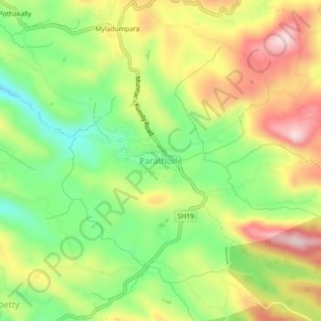
Name: Parathode topographic map, elevation, terrain.
Location: Parathode, Udumbanchola, Idukki, Kerala, 685554, India (9.85449 77.14148 9.89449 77.18148)
Average elevation: 1,046 m
Minimum elevation: 906 m
Maximum elevation: 1,208 m
Thank you for supporting this site ❤️
Make a donation
Make a donation
Gear up for your next adventure:
As an Amazon Associate, this site earns from qualifying purchases at no extra cost to you.