Geolocate

Leiston topographic map

Click on the map to display elevation.

About this map

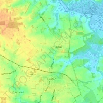
Name: Leiston topographic map, elevation, terrain.

Location: Leiston, East Suffolk, Suffolk, England, United Kingdom (52.19456 1.54962 52.24587 1.62928)

Average elevation: 14 m

Minimum elevation: -3 m

Maximum elevation: 31 m

Gear up for your next adventure:

🪑Ultralight Camping Stool - Compact seating for rest stops during long hikes
Lightweight Backpacking Tent - Compact tent for efficient hiking trips
🧥Insulated Jacket - Keep warm in cold outdoor conditions
🧥Packable Rain Jacket - Breathable waterproof layer for unpredictable weather
🛶Canoe Life Vest - Safety vest for water sports

As an Amazon Associate, this site earns from qualifying purchases at no extra cost to you.