Geolocate

Poo topographic map

Click on the map to display elevation.

About this map

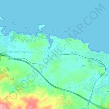
Name: Poo topographic map, elevation, terrain.

Location: Poo, Llanes, Asturias, 33509, España (43.40432 -4.80316 43.44432 -4.76316)

Average elevation: 23 m

Minimum elevation: -3 m

Maximum elevation: 126 m

Other topographic maps

Click on a map to view its topography, its elevation and its terrain.

Meré

España > Asturias > Llanes

Average elevation: 351 m

Río de Nueva

España > Asturias > Llanes > Picones

Average elevation: 25 m

Gear up for your next adventure:

🥤Collapsible Travel Cup - Saves space and weight in your mess kit
🧼Biodegradable Camp Soap - Environmentally friendly cleaning for gear and body
🩹Moleskin Blister Pads - Direct protection for painful foot pressure points
🔦UV Flashlight - Detect minerals or specific insects in the dark
🧥Ultralight Puffy Jacket - Maximum warmth that packs down to the size of an orange

As an Amazon Associate, this site earns from qualifying purchases at no extra cost to you.