
Viacha topographic map
Click on the map to display elevation.
About this map
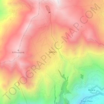
Name: Viacha topographic map, elevation, terrain.
Location: Viacha, Pisac, Province of Calca, Cusco, 08106, Peru (-13.41103 -71.86933 -13.37103 -71.82933)
Average elevation: 3,905 m
Minimum elevation: 3,105 m
Maximum elevation: 4,428 m
Other topographic maps
Click on a map to view its topography, its elevation and its terrain.
Pisaq National Archaeological Park
The town is located in the district of Pisac, province of Calca at the southern end of the Sacred Valley at an altitude of 2,972 metres (9,751 ft), 32 kilometres (20 mi) northeast of Cusco. The town straddles the Vilcanota River with most of the settlement on its right bank, where it is laid out in a grid…
Average elevation: 3,848 m