Geolocate

Red Crater topographic map

Click on the map to display elevation.

About this map

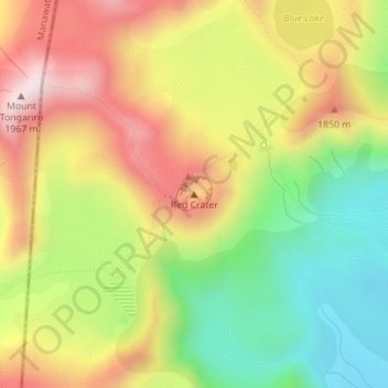
Name: Red Crater topographic map, elevation, terrain.

Location: Red Crater, Taupō District, Waikato, New Zealand (-39.13678 175.65086 -39.13668 175.65096)

Average elevation: 1,678 m

Minimum elevation: 1,421 m

Maximum elevation: 1,951 m

Other topographic maps

Click on a map to view its topography, its elevation and its terrain.

Hauhungaroa Range

New Zealand > Waikato > Taupo District

Average elevation: 753 m

Tongariro River

New Zealand > Waikato > Taupo District

Average elevation: 853 m

Lake Rotoaira

New Zealand > Waikato > Taupo District

Average elevation: 624 m

Lake Rotokawa

New Zealand > Waikato > Taupo District

Average elevation: 358 m

Lake Rotopounamu

New Zealand > Waikato > Taupo District

Average elevation: 784 m

Summit Plateau

New Zealand > Waikato > Taupo District

Average elevation: 2,454 m

Motutaiko Island

New Zealand > Waikato > Taupo District

Average elevation: 357 m

Gear up for your next adventure:

🧊Insulated Water Bottle - Keeps drinks cold in summer and prevents freezing in winter
🧭GPS Tracker - Track your location in remote areas safely
🧥Thermal Layer - Insulating layer for cold outdoor conditions
🧢Outdoor Visor - Breathable visor for sunny hikes
👟Sport Hiking Sandals - Breathable footwear for water crossings and camp rest

As an Amazon Associate, this site earns from qualifying purchases at no extra cost to you.